数字地球移动应用程序
The DIGITAL EARTH mobile app beta version, developed by the specialists of our Institute, has been published by the ROSCOSMOS State Corporation in Google Play and now it is awaiting its placement in other app stores.
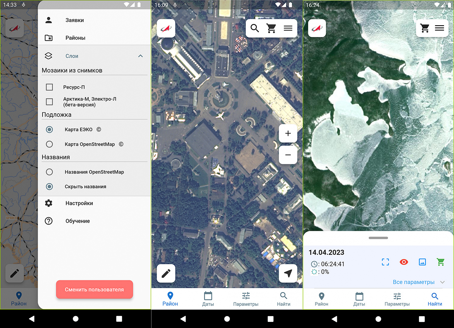
The DIGITAL EARTH mobile app, designed for tablets/smartphones with Android and iOS operating systems is a service, that provides access to satellite imagery of Earth both for professionals and for users without special skills. The mobile app enables users to fulfill image retrieval process, by specifying the desired area of interest, desired time range and other parameters; to browse satellite images from the entire Earth’s surface on the map; to make queries and orders for satellite image-based geo-products, by selecting appropriate processing parameters; to view the ordered geo-products, having placed them on the maps; to subscribe to email notification to receive new imagery for the area of their interests.
While building the DIGITAL EARTH information system has not been completed, images from the Federal ERS Data Fund are available for search in the mobile app beta version: 85 thousand ultra-high resolution images (70 cm/pixel), captured by the SANGUR-1U camera, mounted aboard the RESURS-P series spacecraft, the last of which completed its operation in September 2021. The Fund continues to receive imagery, acquired from the Panchromatic/Multispectral imaging system instruments, installed within the CANOPUS-V series satellites, it now comprises more than 154,000 high-resolution images (up to 3 m/pixel).
Quite a lot of images can be viewed – in whole or in part - in full resolution on the map. This option is provided for images, processed by software suites, developed by Space Rocket Center PROGRESS and VNIIEM Corporation.
The user for each of the images can order its data product, using the software package developed by RIPI. This service is rendered free for state companies; individuals and commercial companies may pay the option via the bank card.
In the LAYERS section, one can select an underlay map, hide or display mosaics of satellite images on it, as well as names of terrain objects that are displayed over images.
Currently, mosaics, generated by software suites, developed by RUSSIAN SPACE SYSTEMS are available as follows: ultra-high resolution mosaics for the territory of Moscow, Leningrad, Kaluga, Bryansk, Belgorod and Kaliningrad regions and the Republic of Crimea; as well as low-resolution mosaics for the vast territories of Eurasia, Africa and North America, which are updated every 15-30 minutes; data from the new acquisitions become available for download within 30 minutes of acquisition by satellites of ARKTIKA-M and ELECTRO-L series.
A number of companies took part in testing the mobile application and web services for storage and providing ERS information products. Such companies were the Scientific Center for Operational Earth Monitoring, the national operator of the Russian ERS satellite constellation; leading organizations of the geoinformation community – RAKURS, TerraTech companies and others. All of them gave favorable reviews about mobile app operation.
Оvnan Tokhiyan, Head of the RIPI unit, said in an interview:
- Within the DIGITAL EARTH information system project and to ensure stable mobile app functioning, our specialists have developed "Subsystems for storage and for providing ERS information products" software tools, which were made with the use of cloud computing technologies and advanced software development technologies.
Web-services are realized on the Central Bank for Geodata (CBGD) software platform, which is the core element of the Integrated Geographically Distributed ERS Information System (IGDERSIT, ETRIS DZZ) and the Federal ERS Data Fund and is responsible for cataloging, long-term and online storage of satellite images and relevant processed products, as well as ensures interaction with users, providing them with the Geoportal and program interface (API).
The CBGD software operates in the Kubernetes (also known as K8s) cloud computing environment, that dynamically manages the number of executing instances of various CBGD programs depending on the number of incoming requests. The single cloud computing and storage cluster is a service for the unified software/hardware Computational Resource Package (CRP), developed and hosted by our Institute within the JSC RUSSIAN SPACE SYSTEM Data Center.
Web-services (web-API) provide users with programming interfaces to ensure and enhance access and usability of information resources of the Integrated Geographically Distributed ERS Information System, and in the future - the DIGITAL EARTH information system, in their application software. At the same time, the possibility of providing machine access via the Internet to publicly available and/or to ordered satellite image-based products using modern protocols, specifications and formats (SpatioTemporal Asset Catalogs (STAC), Amazon Simple Storage Service (S3), Cloud Optimized GeoTIFF (COG)) makes this resource very appealing for professional users. This allows users to fulfill online additional thematic data processing, using their own resources, without prior downloading the image files to their server.
Once the DIGITAL EARTH system is completed, data products of all full resolution images, as well as mosaics from medium, high, ultra-high resolution satellite images will have to be transmitted to the "Subsystem for storage and for providing ERS information products" from the "Data processing subsystem" and "Data storage subsystem", which are currently being developed as the separate software and hardware components of the system. The mosaics will eventually be formed in conformity with approved regulations, for the territory of Russia, at specified intervals, for example, once a year – with ultra–high resolution; once a quarter – with high resolution; once a month – with medium resolution; and as well as for orders made by users via the Geoportal and user interfaces.
The mobile app will still face the important trials as part of the DIGITAL EARTH information system, but its beta version can already be downloaded from Google Play today, and very soon it will be available in the AppStore and RuStore.
RIPI Press Service