RIPI built unique software
RIPI specialists have developed a unique software, that has no analogues in Russia and enables automatic generation of high-precision seamless orthomosaics, based on data captured from the Remote Sensing spacecraft constellation.
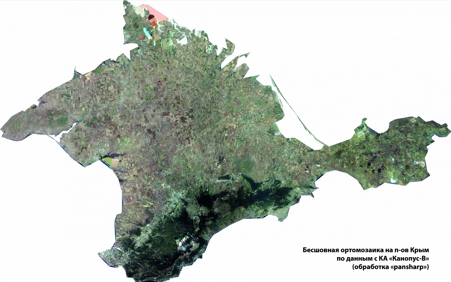
Seamless orthomosaics (seamless continuous coverage) is the result of joining ("stitching") several images of the Earth's surface into one continuous balanced image of a large area.
Dmitry Fedotkin, head of the RIPI unit, said in an interview:
- While processing large data arrays, the so-called block equalization is carried out to remove mutual distortions in the overlapping zones between the adjacent images. Next, each original image is transformed in a way to eliminate geometrical distortions, caused by the terrain impact and the method of image acquisition; to eliminate temporal distortion between two time series brightness adjustment is accomplished; "stitching" lines are formed along which the images will be merged into a single final image. As a result, a single seamless color-balanced image is obtained, covering significant territories and having similar accuracy characteristics over its entire area.
An orthomosaic map can be used as an independent measuring tool, for example, to make accurate distance measurements, when satellite or aerial survey materials are needed for large areas of the Earth's surface. Such a seamless orthomosaic provides the basis both for building and updating multi-scale topographic maps and plans, and for the purposes of monitoring and production of thematic maps.
Full automation in manufacturing seamless orthomosaics has become a natural extension of activities aimed at building the Automatic Streaming Data Processing Complex (ADSP, the Complex), which began in 2016.
The ADSP was designed as part of the Integrated Geographically Distributed ERS Information System (IGDERSIS) to ensure the Federal ERS Data Fund is able to operate. For more than two years, the Complex has been operated by the Scientific Center for Operational Earth Monitoring, the national operator of the Russian ERS satellite constellation of the Russian Space Systems Holding. The ADSP accomplishes fully automatic (without participation of operators) high-rate and high-quality processing of large amounts of archival and operational data, captured from the high- and medium-resolution ERS spacecraft constellations: RESURS-P, CANOPUS-V, METEOR-M. To date, the Complex peak performance has reached about 1.5 million sq. km per day.
The full automation of all process stages permitted eliminating an infamous human factor, substantially improving the quality and processing speed – from several hours, and sometimes days to several minutes and even seconds. A number of the technical assets used was also decreased by an order, which, as consequence, over time would result in a considerable reduction of operational costs.
One of the main tools within the ADSP Complex, that ensures the required quality of output images, complied with the set georeference and stitching of matrices and channels, is the refinement of the spacecraft motion parameters and its orientation.
Tens of thousands of fulfilled customers’ requests, by which the statistics of the Federal ERS Data Fund operation are compiled, have shown that the strict mathematical survey model-based algorithms developed for refining on-board navigation data, have significantly improved the accuracy of georeference of output information products from several tens and hundreds (and sometimes thousands) up to a few meters.
The ERS data processing algorithms, developed while designing the ADSP Complex and having tested during operation of the Federal ERS Data Fund, formed the basis for the software, designed for the automatic generation of high-precision seamless orthomosaics for the benefit of users.
One of the distinctions of the developed software is the maximized use of strict mathematical models, algorithms and image processing approaches, that enables a user to eliminate quickly, automatically and with high accuracy the root causes of errors (for example, in terms of georeference) without carrying out labor-intensive and time-consuming correction of numerous consequences, resulting on the final images. One of the main stages in generation of orthomosaics, namely block equalization of a set of images, is also accomplished based on strict survey model, and not according to frequently used simplified models.
When creating this software, our Institute’s specialists used the modern neural network algorithms that significantly increased the quality of the orthomosaic coatings generated both in terms of combining individual images and their spectral channels with each other, and in terms of the resultant accuracy of the georeferencing.
The visual quality of the built orthomosaics is also largely determined by the automatic algorithms, used for generating lines of "stitching" images and their color balancing.
Of particular note is that the built software allows obtaining high-precision seamless orthomosaics over large areas with pixel accuracy. And yet, the resultant accuracy of georeference does not exceed several meters and is practically independent of the initial errors of onboard navigation measurements, which can be hundreds of meters.
The software developed by the RIPI specialists will enable the users to generate quickly, and above all, in fully automatic mode seamless orthomosaic coatings based on the data captured from the Russian Remote Sensing satellite constellation to the benefit of end-users, both within the DIGITAL EARTH information system, that is presently being set up, and in promising projects.
This project will provide an excellent basis for functioning the ground-based segment of Russian Remote Sensing constellation, used for stream processing of large amount of data, which is expected to be acquired from the future national multi-satellite constellation.
RIPI Press Service